Rough doris (Onchidoris muricata)
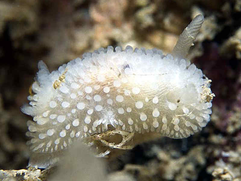
Onchidoris muricata.
Photographer: Jim Anderson Copyright: Jim Anderson
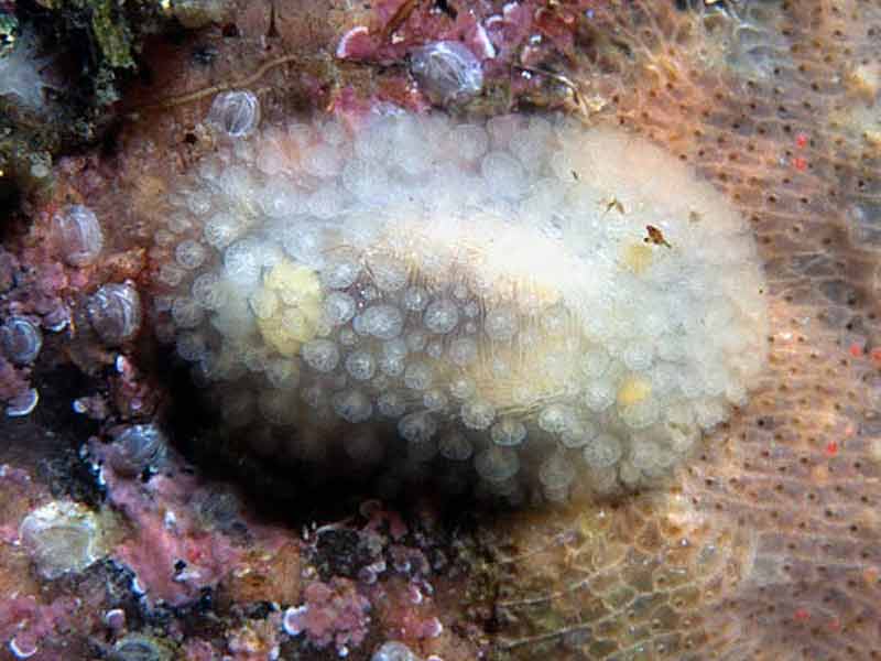
Dorsal view of Onchidoris muricata.
Photographer: Jim Anderson Copyright: Jim Anderson
Distribution data supplied by the Ocean Biodiversity Information System (OBIS). To interrogate UK data visit the NBN Atlas.Map Help
| Researched by | Rose Edwards | Refereed by | Admin |
| Authority | (O. F. Müller, 1776) | ||
| Other common names | - | Synonyms | - |
Summary
Description
Onchidoris muricata has a maximum length of 1.4 cm and is usually white in colour but pale yellow individuals have been recorded. Also some rare individuals have been recorded with brown speckling on the mantle. Club-shaped stalked projections (tubercles) are visible on its mantle. Up to 11 gills can also be found at the rear of the mantle. The head is extended to form an oral veil, which lacks tentacles. The eggs are spawned in a ribbon, coiled several times.
Recorded distribution in Britain and Ireland
More common on the west coast of the British Isles particularly in the north. Few recordings on the east coast of the British Isles.Global distribution
This widespread species has been recorded on both sides of the north Atlantic, and in Alaska, British Columbia and Washington in the north Pacific.Habitat
Onchidoris muricata is found on the lower shore or in sublittoral areas to depths of 15 m.Depth range
-Identifying features
- Grows up to 1.4 cm.
- White or pale yellow in colour.
- Rounded tubercles with flattened tops.
Additional information
Likely to be confused with Adalaria proxima, however Onchidoris muricata has club-shaped tubercles whereas Adalaria proxima tentacles are pointed. Also Adalaria proxima is a large species, it can grow to 1.7 cm in length.
Listed by
- none -
Bibliography
Hayward, P.J. & Ryland, J.S. (ed.), 1995. The marine fauna of the British Isles and north-west Europe. Volume 2. Molluscs to Chordates. Oxford Science Publications. Oxford: Clarendon Press.
Howson, C.M. & Picton, B.E., 1997. The species directory of the marine fauna and flora of the British Isles and surrounding seas. Belfast: Ulster Museum. [Ulster Museum publication, no. 276.]
JNCC (Joint Nature Conservation Committee), 1999. Marine Environment Resource Mapping And Information Database (MERMAID): Marine Nature Conservation Review Survey Database. [on-line] http://www.jncc.gov.uk/mermaid
Picton, B. E. & Morrow, C.C., 1994. A Field Guide to the Nudibranchs of the British Isles. London: Immel Publishing Ltd.
Picton, B.E. & Morrow, C.C., 2000. Encyclopaedia of Marine Life of Britain and Ireland. http://www.habitas.org.uk/marinelife/index.html, 2003-09-18
Picton, B.E., 2000. Nudibranchs of the British Isles. http://www.pictonb.freeserve.co.uk/nudibranchs/index.html, 2003-09-11
Thompson, T. E. & Brown, G. H., 1976. British Opisthobranch Molluscs. London: Academic Press. [Synopses of the British Fauna, no. 8.]
Datasets
Bristol Regional Environmental Records Centre, 2017. BRERC species records recorded over 15 years ago. Occurrence dataset: https://doi.org/10.15468/h1ln5p accessed via GBIF.org on 2018-09-25.
Centre for Environmental Data and Recording, 2018. Ulster Museum Marine Surveys of Northern Ireland Coastal Waters. Occurrence dataset https://www.nmni.com/CEDaR/CEDaR-Centre-for-Environmental-Data-and-Recording.aspx accessed via NBNAtlas.org on 2018-09-25.
Conchological Society of Great Britain & Ireland, 2018. Mollusc (marine) data for Great Britain and Ireland - restricted access. Occurrence dataset: https://doi.org/10.15468/4bsawx accessed via GBIF.org on 2018-09-25.
Conchological Society of Great Britain & Ireland, 2018. Mollusc (marine) records for Great Britain and Ireland. Occurrence dataset: https://doi.org/10.15468/aurwcz accessed via GBIF.org on 2018-09-25.
Environmental Records Information Centre North East, 2018. ERIC NE Combined dataset to 2017. Occurrence dataset: http://www.ericnortheast.org.ukl accessed via NBNAtlas.org on 2018-09-38
Fenwick, 2018. Aphotomarine. Occurrence dataset http://www.aphotomarine.com/index.html Accessed via NBNAtlas.org on 2018-10-01
Fife Nature Records Centre, 2018. St Andrews BioBlitz 2015. Occurrence dataset: https://doi.org/10.15468/xtrbvy accessed via GBIF.org on 2018-09-27.
Kent Wildlife Trust, 2018. Kent Wildlife Trust Shoresearch Intertidal Survey 2004 onwards. Occurrence dataset: https://www.kentwildlifetrust.org.uk/ accessed via NBNAtlas.org on 2018-10-01.
NBN (National Biodiversity Network) Atlas. Available from: https://www.nbnatlas.org.
OBIS (Ocean Biodiversity Information System), 2024. Global map of species distribution using gridded data. Available from: Ocean Biogeographic Information System. www.iobis.org. Accessed: 2024-04-19
Outer Hebrides Biological Recording, 2018. Invertebrates (except insects), Outer Hebrides. Occurrence dataset: https://doi.org/10.15468/hpavud accessed via GBIF.org on 2018-10-01.
South East Wales Biodiversity Records Centre, 2018. SEWBReC Molluscs (South East Wales). Occurrence dataset: https://doi.org/10.15468/jos5ga accessed via GBIF.org on 2018-10-02.
South East Wales Biodiversity Records Centre, 2018. Dr Mary Gillham Archive Project. Occurance dataset: http://www.sewbrec.org.uk/ accessed via NBNAtlas.org on 2018-10-02
Citation
This review can be cited as:
Last Updated: 08/04/2004
