Beaked tasselweed (Ruppia maritima)
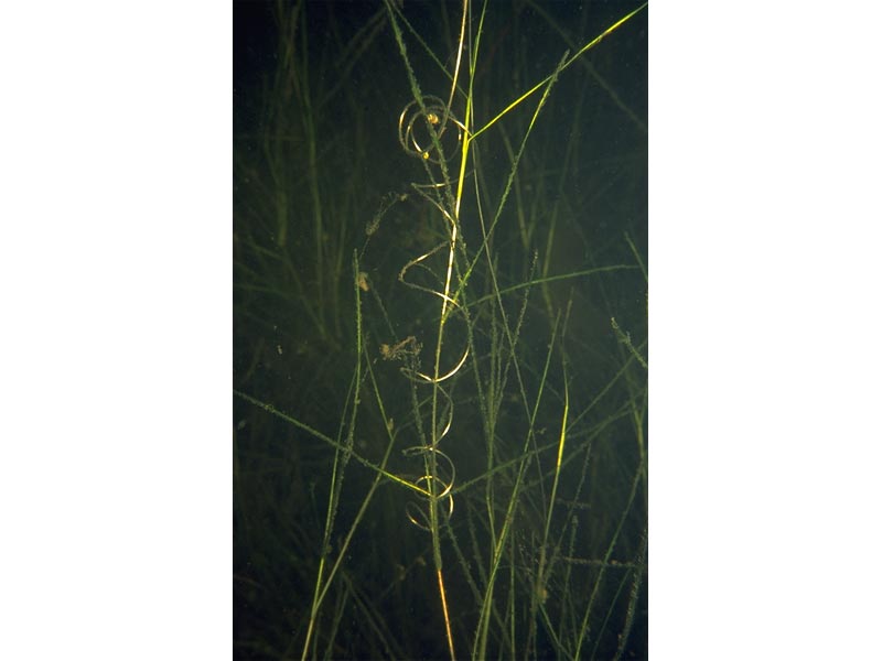
A dense stand of Ruppia sp.
Photographer: Sue Scott Copyright: Sue Scott
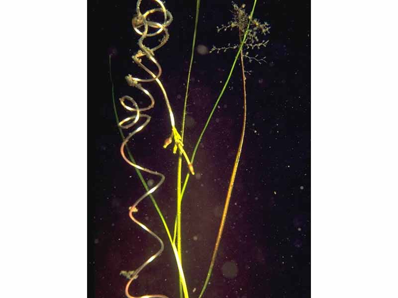
Close up of inflorescence of Ruppia sp.
Photographer: Sue Scott Copyright: Sue Scott
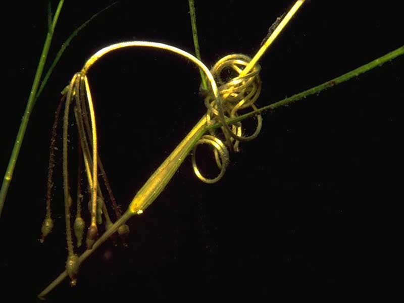
Close up of inflorescense of Ruppia sp.
Photographer: Sue Scott Copyright: Sue Scott
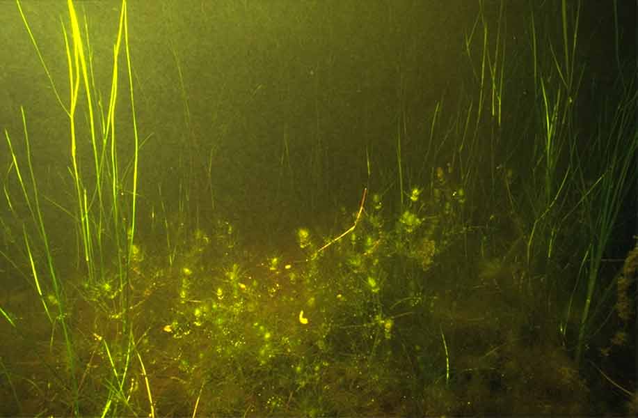
Stand of Ruppia sp. with the foxtail stonewort Lamprothamnion papulosum in foreground.
Photographer: Sue Scott Copyright: Sue Scott
Distribution data supplied by the Ocean Biodiversity Information System (OBIS). To interrogate UK data visit the NBN Atlas.Map Help
| Researched by | Dr Harvey Tyler-Walters | Refereed by | Admin |
| Authority | Linnaeus, 1753 | ||
| Other common names | - | Synonyms | - |
Summary
Description
Recorded distribution in Britain and Ireland
Found all around the British coast wherever suitable habitat exists, as well as in brackish inland waters near Nantwich and Sanbach, Cheshire.Global distribution
Ruppia maritima is a cosmopolitan species whose distribution is limited by the distribution of its habitat, between ca 69 deg N and ca 55 deg S.Habitat
Ruppia maritima grows in soft sediments in sheltered shallow coastal waters, from full salinity to nearly freshwater but mainly in brackish waters of lagoonal habitats, lochs, estuaries, creeks and pools in salt marshes, wetlands, ditches and lakes.Depth range
-Identifying features
- Very slender stems, up to 0.4 m long, sparingly to richly branched.
- Leaves, 0.35 -0.9mm wide, 20 -115 mm long, bright green with pointed (acute) slightly toothed tips.
- Leaves ca 50 -210 times as long as wide.
- Leave sheaths present, 5 -22 mm long.
- Inflorescence borne on a slender, straight or tightly coiled peduncle, 12 -26mm in length but 0.5 -1.8 times as long as the longest carpel stalk.
- Inflorescence of two flowers each with 3-5 carpels.
- Seeds (duplets) pear-shaped, 2-2.8mm by 1.3-1.8mm, dark brown, with wine-red tubercles on surface.
Additional information
The taxonomy of Ruppia spp. is difficult and under revision. Ruppia maritima may be confused with Ruppia cirrhosa (syn. spiralis), which has dark green, wider (0.4 -1.4 mm) elongate leaves, with blunt tips, and whose flowers have a relatively longer peduncle (Preston, 1995). Dwarf forms of Ruppia maritima may be confused with the needle spike-rush Eleocharis acicularis.Listed by
- none -
Bibliography
Cronquist, A., 1988. The evolution and classification of flowering plants (2nd edn). New York: New York Botanical Garden.
JNCC (Joint Nature Conservation Committee), 1999. Marine Environment Resource Mapping And Information Database (MERMAID): Marine Nature Conservation Review Survey Database. [on-line] http://www.jncc.gov.uk/mermaid
Kantrud, H.A., 1991. Wigeongrass (Ruppia maritima L.): a literature review. [On-line.] http://www.npwrc.usgs.gov/resource/literatr/ruppia/ruppia.htm, 2001-10-19
Preston, C.D., 1995. Pondweeds of Great Britain and Ireland. London: Botanical Society of the British Isles. [B.S.B.I. Handbook no. 8.]
Rodwell, J.S. (ed.), 2000. British plant communities, vol. 5, Maritime communities and vegetation of open habitats. Cambridge: Cambridge University Press.
Verhoeven, J.T.A., 1979. The ecology of Ruppia-dominated communities in western Europe. I. Distribution of Ruppia representatives in relation to their autecology. Aquatic Botany, 6,197-268.
Verhoeven, J.T.A., 1980a. The ecology of Ruppia-dominated communities in western Europe. II. Synecological classification. Structure and dynamics of the macroflora and macrofaunal communities. Aquatic Botany, 8, 1-85.
Verhoeven, J.T.A., 1980b. The ecology of Ruppia-dominated communities in western Europe. III. Aspects of production, consumption and decomposition. Aquatic Botany, 8, 209-253.
Datasets
Botanical Society of Britain & Ireland, 2018. Other BSBI Scottish data up to 2012. Occurrence dataset: https://doi.org/10.15468/2dohar accessed via GBIF.org on 2018-09-25.
Botanical Society of Britain & Ireland, 2018. Scottish SNH-funded BSBI records. Occurrence dataset: https://doi.org/10.15468/llasrt accessed via GBIF.org on 2018-09-25.
Botanical Society of Britain & Ireland, 2018. Welsh BSBI data (ex-VPDB dataset) at hectad resolution. Occurrence dataset: https://doi.org/10.15468/rsvnif accessed via GBIF.org on 2018-09-25.
Bristol Regional Environmental Records Centre, 2017. BRERC species records recorded over 15 years ago. Occurrence dataset: https://doi.org/10.15468/h1ln5p accessed via GBIF.org on 2018-09-25.
Centre for Environmental Data and Recording, 2018. Ulster Museum Marine Surveys of Northern Ireland Coastal Waters. Occurrence dataset https://www.nmni.com/CEDaR/CEDaR-Centre-for-Environmental-Data-and-Recording.aspx accessed via NBNAtlas.org on 2018-09-25.
Cofnod – North Wales Environmental Information Service, 2018. Miscellaneous records held on the Cofnod database. Occurrence dataset: https://doi.org/10.15468/hcgqsi accessed via GBIF.org on 2018-09-25.
Cumbria Biodiversity Data Centre, 2018. Tullie House Museum Natural History Collections. Occurrence dataset: https://doi.org/10.15468/epewfs accessed via GBIF.org on 2018-09-25.
Environmental Records Information Centre North East, 2018. ERIC NE Combined dataset to 2017. Occurrence dataset: http://www.ericnortheast.org.ukl accessed via NBNAtlas.org on 2018-09-38
Fenwick, 2018. Aphotomarine. Occurrence dataset http://www.aphotomarine.com/index.html Accessed via NBNAtlas.org on 2018-10-01
Lancashire Environment Record Network, 2018. LERN Records. Occurrence dataset: https://doi.org/10.15468/esxc9a accessed via GBIF.org on 2018-10-01.
Merseyside BioBank., 2017. Merseyside BioBank (verified). Occurrence dataset: https://doi.org/10.15468/ar0p6s accessed via GBIF.org on 2018-10-01.
National Trust, 2017. National Trust Species Records. Occurrence dataset: https://doi.org/10.15468/opc6g1 accessed via GBIF.org on 2018-10-01.
NBN (National Biodiversity Network) Atlas. Available from: https://www.nbnatlas.org.
Norfolk Biodiversity Information Service, 2017. NBIS Records to December 2016. Occurrence dataset: https://doi.org/10.15468/jca5lo accessed via GBIF.org on 2018-10-01.
OBIS (Ocean Biodiversity Information System), 2025. Global map of species distribution using gridded data. Available from: Ocean Biogeographic Information System. www.iobis.org. Accessed: 2025-07-08
Record, 2017. RECORD Vascular Plant Data. Occurrence dataset https://doi.org/10.15468/nmdcir accessed via GBIF.org on 2018-10-02.
Royal Botanic Garden Edinburgh, 2018. Royal Botanic Garden Edinburgh Herbarium (E). Occurrence dataset: https://doi.org/10.15468/ypoair accessed via GBIF.org on 2018-10-02.
South East Wales Biodiversity Records Centre, 2018. SEWBReC Vascular Plants (South East Wales). Occurrence dataset: https://doi.org/10.15468/7qjujd accessed via GBIF.org on 2018-10-02.
South East Wales Biodiversity Records Centre, 2018. Dr Mary Gillham Archive Project. Occurance dataset: http://www.sewbrec.org.uk/ accessed via NBNAtlas.org on 2018-10-02
Suffolk Biodiversity Information Service., 2017. Suffolk Biodiversity Information Service (SBIS) Dataset. Occurrence dataset: https://doi.org/10.15468/ab4vwo accessed via GBIF.org on 2018-10-02.
Citation
This review can be cited as:
Last Updated: 19/10/2001
