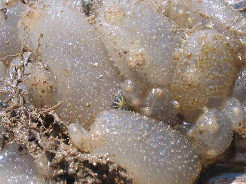
Fluted sea squirt (Ascidiella aspersa)
Distribution data supplied by the Ocean Biodiversity Information System (OBIS). To interrogate UK data visit the NBN Atlas.Map Help
| Researched by | Lisa Curtis | Refereed by | Admin |
| Authority | (Müller, 1776) | ||
| Other common names | - | Synonyms | - |
Summary
Description
This species is solitary but commonly found in dense unfused aggregations. The body is ovoid in shape, up to 130mm long and usually attached to the substratum by the left side. The test or layer that encloses the body is firm to touch, thick, rough and gristly, and is greyish-black or brown in colour, often with attached detritus.
Recorded distribution in Britain and Ireland
Common on all British coasts but appears to be more common on south and west coasts.Global distribution
Common throughout NE Atlantic, from W Norway to Mediterranean.Habitat
Found in the lower intertidal and sublittorally to 80 m. Will tolerate salinities as low as 18 psu and is therefore, often found in estuaries.Depth range
Lower intertidal to ca. 80mIdentifying features
- The inhalent siphon is terminal, with the exhalent siphon about 1/3 down the edge of the body.
- Siphons may sometimes be frilled.
- A ring of 30-40 well separated, slender tentacles maybe found.
Additional information
No text entered
Listed by
- none -
Bibliography
Fish, J.D. & Fish, S., 1996. A student's guide to the seashore. Cambridge: Cambridge University Press.
Hayward, P., Nelson-Smith, T. & Shields, C. 1996. Collins pocket guide. Sea shore of Britain and northern Europe. London: HarperCollins.
Hayward, P.J. & Ryland, J.S. (ed.) 1995b. Handbook of the marine fauna of North-West Europe. Oxford: Oxford University Press.
Howson, C.M. & Picton, B.E., 1997. The species directory of the marine fauna and flora of the British Isles and surrounding seas. Belfast: Ulster Museum. [Ulster Museum publication, no. 276.]
Stachowitsch, M., 1984. Mass mortality in the Gulf of Trieste: the course of community destruction. Marine Ecology, Pubblicazione della Statione Zoologica di Napoli, 5, 243-264.
Datasets
Centre for Environmental Data and Recording, 2018. IBIS Project Data. Occurrence dataset: https://www.nmni.com/CEDaR/CEDaR-Centre-for-Environmental-Data-and-Recording.aspx accessed via NBNAtlas.org on 2018-09-25.
Centre for Environmental Data and Recording, 2018. Ulster Museum Marine Surveys of Northern Ireland Coastal Waters. Occurrence dataset https://www.nmni.com/CEDaR/CEDaR-Centre-for-Environmental-Data-and-Recording.aspx accessed via NBNAtlas.org on 2018-09-25.
Fenwick, 2018. Aphotomarine. Occurrence dataset http://www.aphotomarine.com/index.html Accessed via NBNAtlas.org on 2018-10-01
Kent Wildlife Trust, 2018. Kent Wildlife Trust Shoresearch Intertidal Survey 2004 onwards. Occurrence dataset: https://www.kentwildlifetrust.org.uk/ accessed via NBNAtlas.org on 2018-10-01.
Merseyside BioBank., 2018. Merseyside BioBank (unverified). Occurrence dataset: https://doi.org/10.15468/iou2ld accessed via GBIF.org on 2018-10-01.
National Trust, 2017. National Trust Species Records. Occurrence dataset: https://doi.org/10.15468/opc6g1 accessed via GBIF.org on 2018-10-01.
NBN (National Biodiversity Network) Atlas. Available from: https://www.nbnatlas.org.
OBIS (Ocean Biodiversity Information System), 2025. Global map of species distribution using gridded data. Available from: Ocean Biogeographic Information System. www.iobis.org. Accessed: 2025-07-26
Citation
This review can be cited as:
Last Updated: 16/08/2005


