Mottled red mail shell (Tonicella marmorea)
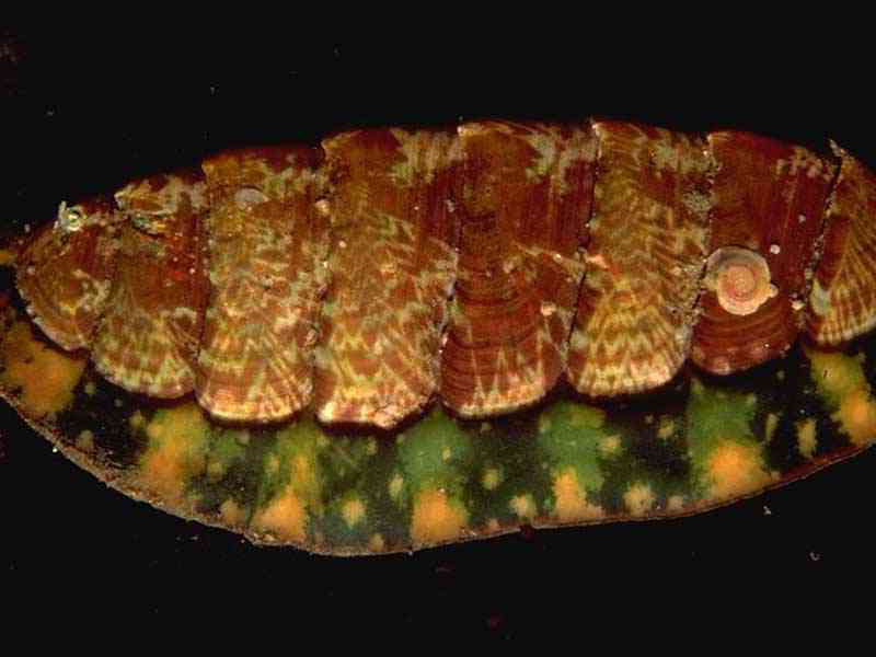
Tonicella marmorea
Photographer: Sue Scott Copyright: Sue Scott
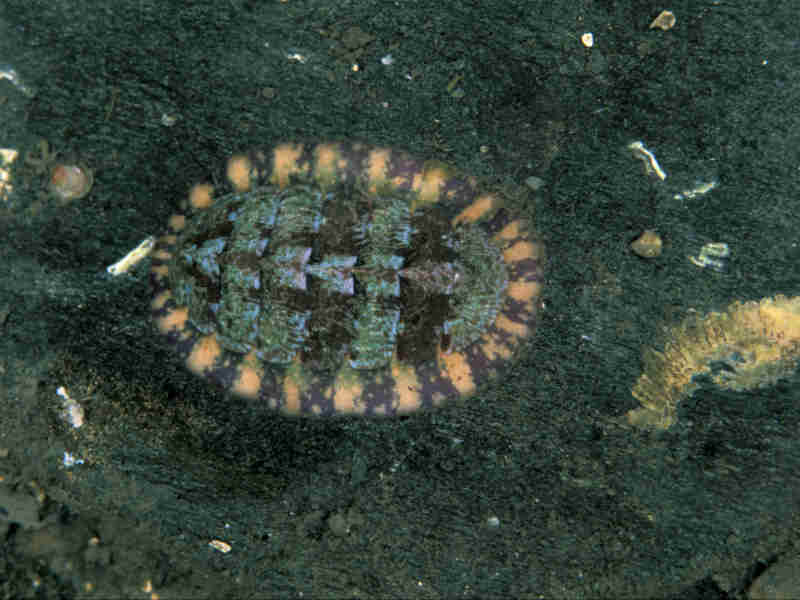
Tonicella marmorea
Photographer: Paul Naylor Copyright: Paul Naylor
Distribution data supplied by the Ocean Biodiversity Information System (OBIS). To interrogate UK data visit the NBN Atlas.Map Help
| Researched by | Marie Skewes | Refereed by | Admin |
| Authority | (O. Fabricius, 1780) | ||
| Other common names | Mottled red chiton, Lined red chiton | Synonyms | - |
Summary
Description
A large, broadly oval chiton, up to 4 cm in length. The shell plates are smooth and glossy, reddish brown in colour with variable white or pale brown marbling. Girdle broad, thin and leathery, reddish-brown with a fringe of tiny, flattened spines (red, green or purple in colour, sometimes banded). The mantle has 17-26 pairs of gills, usually in the posterior region of the mantle groove but occasionally distributed throughout the entire groove.
Recorded distribution in Britain and Ireland
A northern species found predominantly in Scotland, northern England and the north of Ireland but recorded as far south as south Devon.Global distribution
An Atlantic-Boreal species reported from the Arctic Ocean and the coasts of Norway, Sweden and Britain, Geenland and the Atlantic coast of North America.Habitat
Found on rocks and stones from the lower shore to depths of about 200 m.Depth range
-Identifying features
- Shell plates with indistinct keels but pronounced beaks.
- Distinct growth bands present.
- Girdle leathery with widely spaced, minute granules
Additional information
A detailed key to the chitons is provided by Jones & Baxter (1987).
Listed by
Bibliography
Fish, J.D. & Fish, S., 1996. A student's guide to the seashore. Cambridge: Cambridge University Press.
Hayward, P., Nelson-Smith, T. & Shields, C. 1996. Collins pocket guide. Sea shore of Britain and northern Europe. London: HarperCollins.
Hayward, P.J. & Ryland, J.S. (ed.) 1995b. Handbook of the marine fauna of North-West Europe. Oxford: Oxford University Press.
Hiscock, K., Southward, A., Tittley, I., Jory, A. & Hawkins, S., 2001. The impact of climate change on subtidal and intertidal benthic species in Scotland. Scottish National Heritage Research, Survey and Monitoring Report , no. 182., Edinburgh: Scottish National Heritage
Howson, C.M. & Picton, B.E., 1997. The species directory of the marine fauna and flora of the British Isles and surrounding seas. Belfast: Ulster Museum. [Ulster Museum publication, no. 276.]
Jones, A.M. & Baxter, J.M., 1987b. Molluscs: Caudofoveata, Solenogastres, Polyplacophora and Scaphopoda. Avon: The Bath Press. [Synopses of the British Fauna No. 37.]
McMillan, N.F., 1968. British Shells. London: Frederick Warne & Co Ltd.
Datasets
Centre for Environmental Data and Recording, 2018. Ulster Museum Marine Surveys of Northern Ireland Coastal Waters. Occurrence dataset https://www.nmni.com/CEDaR/CEDaR-Centre-for-Environmental-Data-and-Recording.aspx accessed via NBNAtlas.org on 2018-09-25.
Conchological Society of Great Britain & Ireland, 2018. Mollusc (marine) data for Great Britain and Ireland - restricted access. Occurrence dataset: https://doi.org/10.15468/4bsawx accessed via GBIF.org on 2018-09-25.
Conchological Society of Great Britain & Ireland, 2023. Mollusc (marine) records for Great Britain and Ireland. Occurrence dataset: https://doi.org/10.15468/aurwcz accessed via GBIF.org on 2024-09-27.
NBN (National Biodiversity Network) Atlas. Available from: https://www.nbnatlas.org.
OBIS (Ocean Biodiversity Information System), 2025. Global map of species distribution using gridded data. Available from: Ocean Biogeographic Information System. www.iobis.org. Accessed: 2025-08-15
Yorkshire Wildlife Trust, 2018. Yorkshire Wildlife Trust Shoresearch. Occurrence dataset: https://doi.org/10.15468/1nw3ch accessed via GBIF.org on 2018-10-02.
Citation
This review can be cited as:
Last Updated: 28/05/2003
