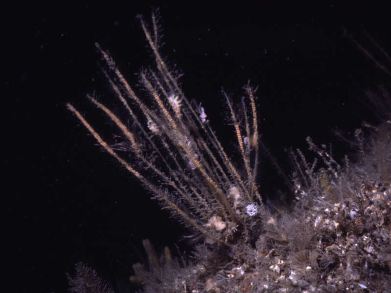
Sea beard (Nemertesia antennina)
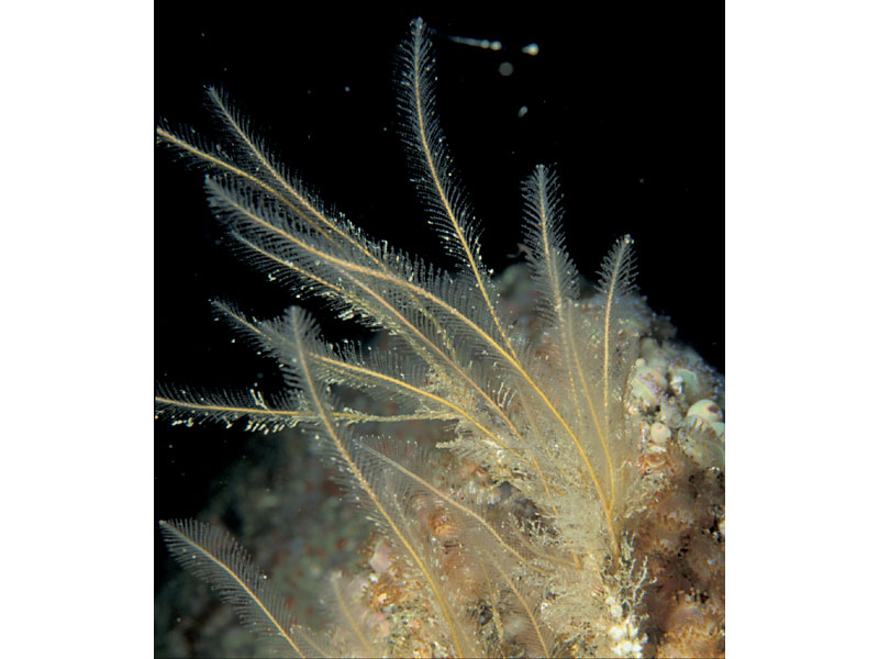
Nemertesia antennina
Photographer: Dr Keith Hiscock Copyright: Dr Keith Hiscock
Nemertesia antennina
Photographer: Paul Newland Copyright: Paul Newland
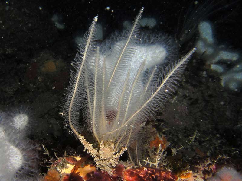
Nemertesia antennina at Mewstone, Plymouth.
Photographer: Paul Newland Copyright: Paul Newland
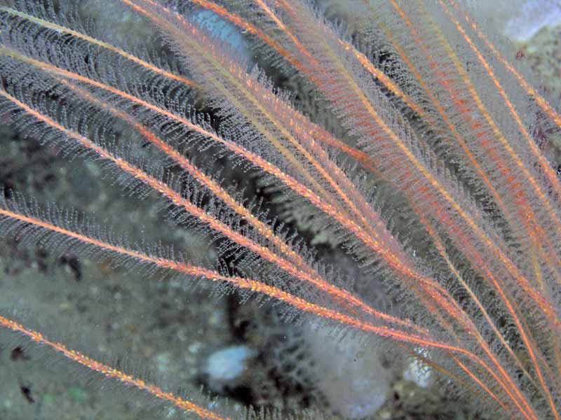
Nemertesia antennina close up.
Photographer: Paul Newland Copyright: Paul Newland
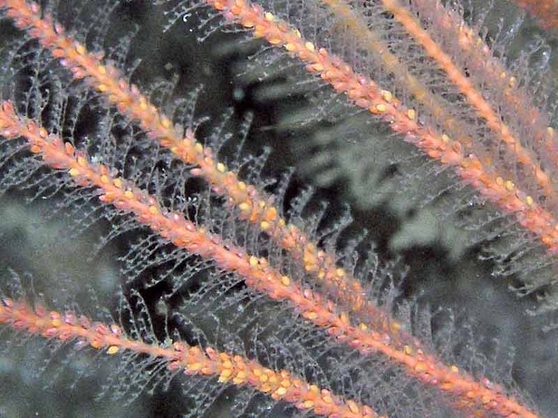
Colony with feeding nudibranchs.
Photographer: Dr Keith Hiscock Copyright: Dr Keith Hiscock
Distribution data supplied by the Ocean Biodiversity Information System (OBIS). To interrogate UK data visit the NBN Atlas.Map Help
| Researched by | Olwen Ager | Refereed by | Admin |
| Authority | (Linnaeus, 1758) | ||
| Other common names | - | Synonyms | - |
Summary
Description
Recorded distribution in Britain and Ireland
Nemertesia antennina is widely distributed around the coasts of Britain and Ireland.Global distribution
Nemertesia antennina is recorded in the northeast Atlantic, from at least the Faroes, Barents Sea and Iceland south through Mauritania to southern Africa, including the Mediterranean, Azores and Madeira.Habitat
Nemertesia antennina is found attached to shells and stones on sandy bottoms from the shallow sublittoral into deeper waters offshore.Depth range
-Identifying features
- Colonial hydroid.
- Up to 50 thick, stiff, erect, stems up to 25 cm tall.
- Stems grow from fibrous mass of rootlets.
- Stems bear bundle of 6-10 whorled side branches.
- Colony is orange-buff in colour.
Additional information
-none-Listed by
- none -
Bibliography
Bradshaw, C., Veale, L.O., Hill, A.S. & Brand, A.R., 2002. The role of scallop-dredge disturbance in long-term changes in Irish Sea benthic communities: a re-analysis of an historical dataset. Journal of Sea Research, 47, 161-184. DOI https://doi.org/10.1016/S1385-1101(02)00096-5
Cornelius, P.F.S., 1995b. North-west European thecate hydroids and their medusae. Part 2. Sertulariidae to Campanulariidae. Shrewsbury: Field Studies Council. [Synopses of the British Fauna no. 50]
Gibson, R., Hextall, B. & Rogers, A., 2001. Photographic guide to the sea and seashore life of Britain and north-west Europe. Oxford: Oxford University Press.
Hayward, P., Nelson-Smith, T. & Shields, C. 1996. Collins pocket guide. Sea shore of Britain and northern Europe. London: HarperCollins.
Hayward, P.J. & Ryland, J.S. (ed.) 1995b. Handbook of the marine fauna of North-West Europe. Oxford: Oxford University Press.
Howson, C.M. & Picton, B.E., 1997. The species directory of the marine fauna and flora of the British Isles and surrounding seas. Belfast: Ulster Museum. [Ulster Museum publication, no. 276.]
Hughes, R.G., 1977. Aspects of the biology and life-history of Nemertesia antennina (L.) (Hydrozoa: Plumulariidae). Journal of the Marine Biological Association of the United Kingdom, 57, 641-657.
Hughes, R.G., 1979. The dispersal and dispersion of some epizoites of the hydroid Nemertesia antennina (L.) Journal of the Marine Biological Association of the United Kingdom, 59, 879-887.
Picton, B.E. & Costello, M.J., 1998. BioMar biotope viewer: a guide to marine habitats, fauna and flora of Britain and Ireland. [CD-ROM] Environmental Sciences Unit, Trinity College, Dublin.
Datasets
Centre for Environmental Data and Recording, 2018. Ulster Museum Marine Surveys of Northern Ireland Coastal Waters. Occurrence dataset https://www.nmni.com/CEDaR/CEDaR-Centre-for-Environmental-Data-and-Recording.aspx accessed via NBNAtlas.org on 2018-09-25.
Dorset Environmental Records Centre, 2018. Ross Coral Mapping Project - NBN South West Pilot Project Case Studies. Occurrence dataset:https://doi.org/10.15468/mnlzxc accessed via GBIF.org on 2018-09-25.
Environmental Records Information Centre North East, 2018. ERIC NE Combined dataset to 2017. Occurrence dataset: http://www.ericnortheast.org.ukl accessed via NBNAtlas.org on 2018-09-38
Fenwick, 2018. Aphotomarine. Occurrence dataset http://www.aphotomarine.com/index.html Accessed via NBNAtlas.org on 2018-10-01
Kent Wildlife Trust, 2018. Kent Wildlife Trust Shoresearch Intertidal Survey 2004 onwards. Occurrence dataset: https://www.kentwildlifetrust.org.uk/ accessed via NBNAtlas.org on 2018-10-01.
Manx Biological Recording Partnership, 2022. Isle of Man historical wildlife records 1990 to 1994. Occurrence dataset:https://doi.org/10.15468/aru16v accessed via GBIF.org on 2024-09-27.
NBN (National Biodiversity Network) Atlas. Available from: https://www.nbnatlas.org.
OBIS (Ocean Biodiversity Information System), 2025. Global map of species distribution using gridded data. Available from: Ocean Biogeographic Information System. www.iobis.org. Accessed: 2025-08-02
South East Wales Biodiversity Records Centre, 2023. SEWBReC Marine and other Aquatic Invertebrates (South East Wales). Occurrence dataset:https://doi.org/10.15468/zxy1n6 accessed via GBIF.org on 2024-09-27.
Citation
This review can be cited as:
Last Updated: 08/05/2008
