Beautiful fan weed (Metacallophyllis laciniata)
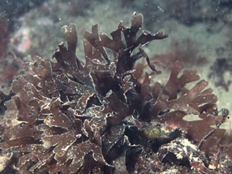
Metacallophyllis laciniata on shallow cobbles.
Photographer: Dr Keith Hiscock Copyright: Dr Keith Hiscock
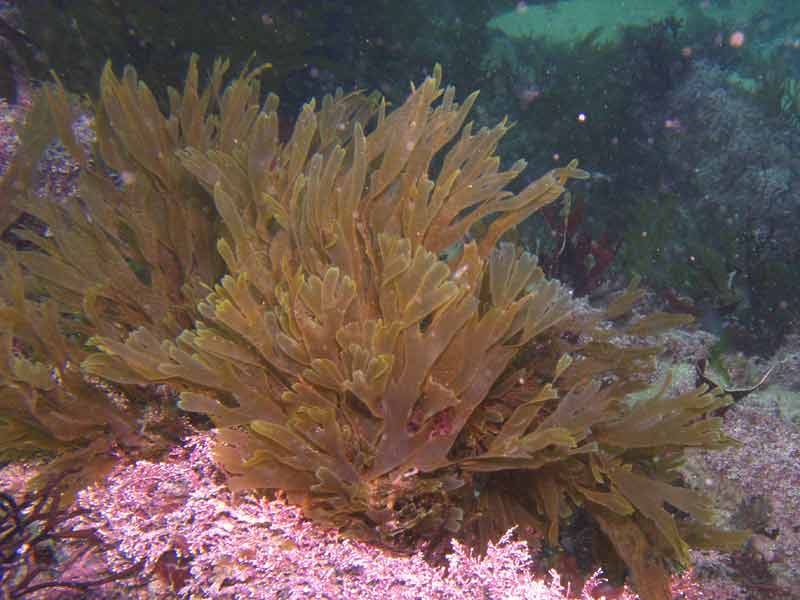
Stand of Metacallophyllis laciniata in shallow water at Outer Hope, Devon.
Photographer: Paul Newland Copyright: Paul Newland
Distribution data supplied by the Ocean Biodiversity Information System (OBIS). To interrogate UK data visit the NBN Atlas.Map Help
| Researched by | Anna Neish | Refereed by | Admin |
| Authority | (Hudson) A.Vergés & L.Le Gall, 2017 | ||
| Other common names | - | Synonyms | Callophyllis lacinata (Hudson) Kützing, 1843 |
Summary
Description
A short soft, fleshy thallus arises and expands immediately from a small round (discoid) holdfast. The stipe is inconspicuous or absent and the crimson, brownish or purple-red fronds are much divided spreading out into wedge-shaped divisions of about 1-3 cm broad. The whole blade can be up to 15 cm long and fan-shaped with overlapping sections. Frond tips are rounded and end in tiny marginal leaflets giving a fringed appearance.
Recorded distribution in Britain and Ireland
Recorded throughout the British Isles, but uncommon in the south east of England between Hampshire and Suffolk, probably due to lack of suitable substrata.Global distribution
Faeroes; Norway and Sweden to Morocco; Mediterranean.Habitat
Metacallophyllis laciniata can be commonly found attached to rock in the lower littoral and shallow sublittoral to at least 30 m. It is also often found attached to kelp stipes and holdfasts on both sheltered and exposed shores.Depth range
-Identifying features
- Soft fleshy red thallus.
- Thallus arising immediately from holdfast.
- No conspicuous stipe.
- Repeatedly branched wedge shaped fronds displaying a fan shaped blade.
Additional information
Often confused with Cryptopleura ramosa with which it often grows and can be distinguished if Cryptopleura ramosa shows iridescence as Metacallophyllis lacinata does not.
Listed by
- none -
Bibliography
Dickinson, C.I., 1963. British seaweeds. London & Frome: Butler & Tanner Ltd.
Hardy, F.G. & Guiry, M.D., 2003. A check-list and atlas of the seaweeds of Britain and Ireland. London: British Phycological Society
Hiscock, S., 1986b. A field key to the British Red Seaweeds. Taunton: Field Studies Council. [Occasional Publication No.13]
Howson, C.M. & Picton, B.E., 1997. The species directory of the marine fauna and flora of the British Isles and surrounding seas. Belfast: Ulster Museum. [Ulster Museum publication, no. 276.]
Irvine, L.M., 1983. Seaweeds of the British Isles vol. 1. Rhodophyta Part 2A. Cryptonemiales (sensu stricto), Palmariales, Rhodymeniales. London: British Museum (Natural History).
Picton, B.E. & Costello, M.J., 1998. BioMar biotope viewer: a guide to marine habitats, fauna and flora of Britain and Ireland. [CD-ROM] Environmental Sciences Unit, Trinity College, Dublin.
Datasets
Centre for Environmental Data and Recording, 2018. Ulster Museum Marine Surveys of Northern Ireland Coastal Waters. Occurrence dataset https://www.nmni.com/CEDaR/CEDaR-Centre-for-Environmental-Data-and-Recording.aspx accessed via NBNAtlas.org on 2018-09-25.
Fenwick, 2018. Aphotomarine. Occurrence dataset http://www.aphotomarine.com/index.html Accessed via NBNAtlas.org on 2018-10-01
Kent Wildlife Trust, 2018. Kent Wildlife Trust Shoresearch Intertidal Survey 2004 onwards. Occurrence dataset: https://www.kentwildlifetrust.org.uk/ accessed via NBNAtlas.org on 2018-10-01.
Manx Biological Recording Partnership, 2017. Isle of Man wildlife records from 01/01/2000 to 13/02/2017. Occurrence dataset: https://doi.org/10.15468/mopwow accessed via GBIF.org on 2018-10-01.
Manx Biological Recording Partnership, 2022. Isle of Man historical wildlife records 1990 to 1994. Occurrence dataset:https://doi.org/10.15468/aru16v accessed via GBIF.org on 2024-09-27.
NBN (National Biodiversity Network) Atlas. Available from: https://www.nbnatlas.org.
OBIS (Ocean Biodiversity Information System), 2025. Global map of species distribution using gridded data. Available from: Ocean Biogeographic Information System. www.iobis.org. Accessed: 2025-07-26
Outer Hebrides Biological Recording, 2018. Non-vascular Plants, Outer Hebrides. Occurrence dataset: https://doi.org/10.15468/goidos accessed via GBIF.org on 2018-10-01.
Royal Botanic Garden Edinburgh, 2018. Royal Botanic Garden Edinburgh Herbarium (E). Occurrence dataset: https://doi.org/10.15468/ypoair accessed via GBIF.org on 2018-10-02.
Citation
This review can be cited as:
Last Updated: 07/11/2006
