A bivalve mollusc (Thracia villosiuscula)
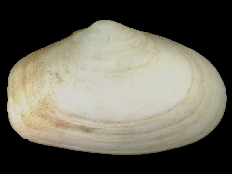
External view of Thracia villosiuscula valve.
Photographer: National Museum Wales Copyright: Amgueddfa Cymru - Museum Wales
Distribution data supplied by the Ocean Biodiversity Information System (OBIS). To interrogate UK data visit the NBN Atlas.Map Help
| Researched by | Anna Neish | Refereed by | Admin |
| Authority | (MacGillivray, 1827) | ||
| Other common names | - | Synonyms | - |
Summary
Description
Recorded distribution in Britain and Ireland
Reported from most parts of the British Isles but uncommon. The extent of distribution is uncertain because of the difficulty of separating Thracia villosiuscula from Thracia phaseolina.Global distribution
From Norway south to the Mediterranean.Habitat
Thracia villosiuscula burrows deeply in coarse sands and coarse fine gravels from the lower shore and shallow sublittoral to depths of about 55 m.Depth range
-Identifying features
- Brittle, white bivalve up to 3 cm long.
- Obliquely truncate posterior margin, slightly gaping.
- Right valve slightly larger and more convex.
- Umbo of left valve sitting in a hole in the umbo of the right.
- Hinge line with a small triangular chondrophore but neither cardinal or lateral teeth are present.
- Proportionally longer posterior hinge line.
Additional information
Difficult to distinguish from Thracia phaseolina but can be told apart by finely granular shell surface, granulations visible with X10 hand lens.Listed by
- none -
Bibliography
Hayward, P., Nelson-Smith, T. & Shields, C. 1996. Collins pocket guide. Sea shore of Britain and northern Europe. London: HarperCollins.
Hayward, P.J. 1994. Animals of sandy shores. Slough, England: The Richmond Publishing Co. Ltd. [Naturalists' Handbook 21.]
Howson, C.M. & Picton, B.E., 1997. The species directory of the marine fauna and flora of the British Isles and surrounding seas. Belfast: Ulster Museum. [Ulster Museum publication, no. 276.]
Picton, B.E. & Costello, M.J., 1998. BioMar biotope viewer: a guide to marine habitats, fauna and flora of Britain and Ireland. [CD-ROM] Environmental Sciences Unit, Trinity College, Dublin.
Tebble, N., 1976. British Bivalve Seashells. A Handbook for Identification, 2nd ed. Edinburgh: British Museum (Natural History), Her Majesty's Stationary Office.
Datasets
Centre for Environmental Data and Recording, 2018. Ulster Museum Marine Surveys of Northern Ireland Coastal Waters. Occurrence dataset https://www.nmni.com/CEDaR/CEDaR-Centre-for-Environmental-Data-and-Recording.aspx accessed via NBNAtlas.org on 2018-09-25.
Conchological Society of Great Britain & Ireland, 2018. Mollusc (marine) data for Great Britain and Ireland - restricted access. Occurrence dataset: https://doi.org/10.15468/4bsawx accessed via GBIF.org on 2018-09-25.
Conchological Society of Great Britain & Ireland, 2023. Mollusc (marine) records for Great Britain and Ireland. Occurrence dataset: https://doi.org/10.15468/aurwcz accessed via GBIF.org on 2024-09-27.
Environmental Records Information Centre North East, 2018. ERIC NE Combined dataset to 2017. Occurrence dataset: http://www.ericnortheast.org.ukl accessed via NBNAtlas.org on 2018-09-38
Merseyside BioBank., 2018. Merseyside BioBank (unverified). Occurrence dataset: https://doi.org/10.15468/iou2ld accessed via GBIF.org on 2018-10-01.
NBN (National Biodiversity Network) Atlas. Available from: https://www.nbnatlas.org.
OBIS (Ocean Biodiversity Information System), 2025. Global map of species distribution using gridded data. Available from: Ocean Biogeographic Information System. www.iobis.org. Accessed: 2025-07-12
Outer Hebrides Biological Recording, 2018. Invertebrates (except insects), Outer Hebrides. Occurrence dataset: https://doi.org/10.15468/hpavud accessed via GBIF.org on 2018-10-01.
Citation
This review can be cited as:
Last Updated: 17/10/2005
