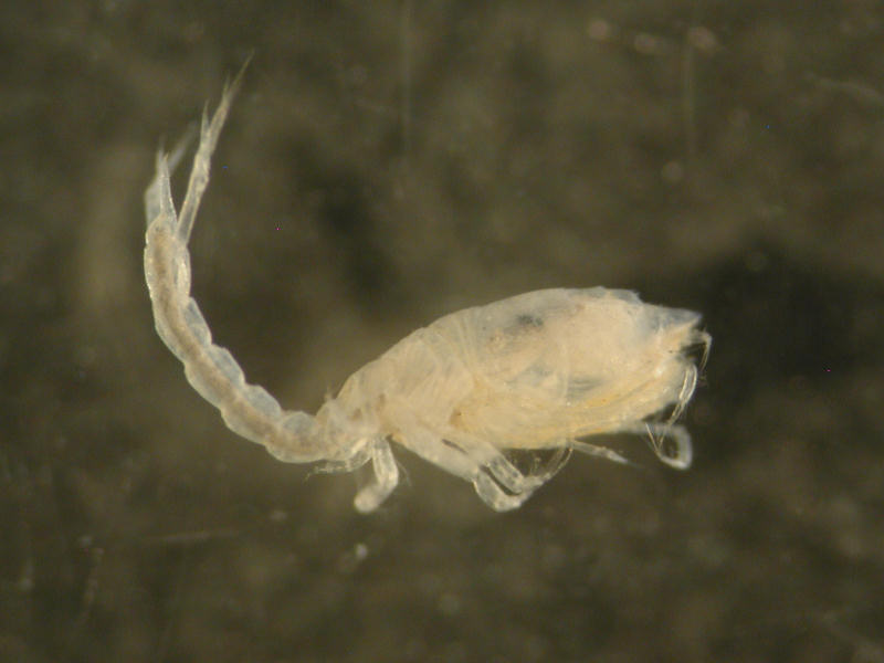
A cumacean (Diastylis rathkei)
Close up of Diastylis rathkei.
Photographer: Crown copyright Copyright: Crown copyright
Distribution data supplied by the Ocean Biodiversity Information System (OBIS). To interrogate UK data visit the NBN Atlas.Map Help
| Researched by | Tracy Heath | Refereed by | Admin |
| Authority | (Krøyer, 1841) | ||
| Other common names | - | Synonyms | - |
Summary
Description
Recorded distribution in Britain and Ireland
Recorded from the Firth of Forth, south to Flamborough Head, the Wash, Harwich, Whitstable, the Severn estuary, Menai Straits, Cumberland, the Solway Firth and Belfast in Northern Ireland.Global distribution
-Habitat
Found burrowing in fine muddy sand on the continental shelf down to depths of 200 m. Fairly common.Depth range
-Identifying features
- Small, tadpole shaped cumacean.
- Length of up to 22 mm but usually smaller.
- Carapace has a pointed tip at the anterior end.
- Antennae small.
- Front appendages covered by carapace.
- Female has rows of denticles along carapace.
- Three pairs of leg like structures at posterior end of carapace.
- Tail made up of six segments.
- Three long, thin structures attached to last segment, forming a fork like tail.
Additional information
Feeds on micro-organisms and organic matter from the bottom deposit. Represented in north west Europe by subspecies typica.Listed by
- none -
Bibliography
Hayward, P., Nelson-Smith, T. & Shields, C. 1996. Collins pocket guide. Sea shore of Britain and northern Europe. London: HarperCollins.
Howson, C.M. & Picton, B.E., 1997. The species directory of the marine fauna and flora of the British Isles and surrounding seas. Belfast: Ulster Museum. [Ulster Museum publication, no. 276.]
JNCC (Joint Nature Conservation Committee), 1999. Marine Environment Resource Mapping And Information Database (MERMAID): Marine Nature Conservation Review Survey Database. [on-line] http://www.jncc.gov.uk/mermaid
Jones, N.S., 1976. British Cumaceans London: Academic Press. [Synopses of the British Fauna, New Series, no. 7.]
Datasets
Bristol Regional Environmental Records Centre, 2017. BRERC species records recorded over 15 years ago. Occurrence dataset: https://doi.org/10.15468/h1ln5p accessed via GBIF.org on 2018-09-25.
NBN (National Biodiversity Network) Atlas. Available from: https://www.nbnatlas.org.
OBIS (Ocean Biodiversity Information System), 2025. Global map of species distribution using gridded data. Available from: Ocean Biogeographic Information System. www.iobis.org. Accessed: 2025-08-05
South East Wales Biodiversity Records Centre, 2018. SEWBReC Myriapods, Isopods, and allied species (South East Wales). Occurrence dataset: https://doi.org/10.15468/rvxsqs accessed via GBIF.org on 2018-10-02.
Citation
This review can be cited as:
Last Updated: 24/11/2005
