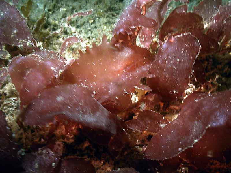
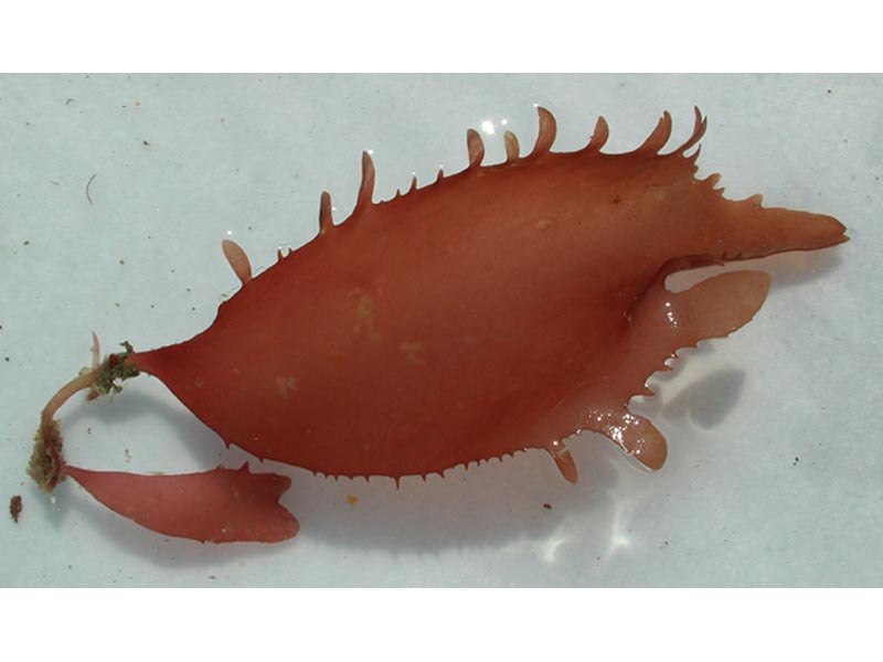
Eyelash weed (Calliblepharis ciliata)
Distribution data supplied by the Ocean Biodiversity Information System (OBIS). To interrogate UK data visit the NBN Atlas.Map Help
| Researched by | Marisa Sabatini | Refereed by | Admin |
| Authority | (Hudson) Kützing, 1843 | ||
| Other common names | - | Synonyms | - |
Summary
Description
Recorded distribution in Britain and Ireland
Recorded on the Orkneys and the coast of Yorkshire but predominently from the south east to the west coast of England, around the coast of Ireland and the west coast of Scotland.Global distribution
-Habitat
Epilithic, occasionally epiphytic. It is found down to depths of 21 m, sometimes extending into pools in the lower littoral. It may also be found forming dense stands on muddy rocks.Depth range
-Identifying features
- Dull red colour.
- Flat oval frond.
- Conspicuous claw like holdfast.
- Ovate shaped lobes.
- Short stem.
- The margins of the blade are fringed with branched or simple branchlets (proliferations) up to 5 mm long and can sometimes appear on the surface of the blade.
Additional information
Calliblepharis ciliata is a gametangial plant with both male and female reproductive organs. The reproductive bodies are not confined to the marginal branchlets but are equally common on those which grow out from the surface of the frond. The male reproductive structures (spermatangia) appear in large superficial sori on young blades. The female reproductive structures (cystocarps) appear as a protruding mass 1- 2 mm in diameter that become visible in September along the margins of the branchlets. The asexual reproductive structures (tetrasporangia) appear in groups of large sori on the blade surface and margins, that grow to 65 to 75 µm x 40 to 45 µm in diameter and are recorded from October to April (Dixon & Irvine, 1977).Calliblepharis ciliata is very similar to Palmaria palmata. However, the latter has a disc shaped holdfast. Calliblepharis jubata is also similar to Calliblepharis ciliata but has several fronds arising from a branched stem and during the summer branches appear long and tendril like. Calliblepharis jubata has a thinner frond, and is normally less than 7 cm broad with longer branchlets (3 cm long). The cystoscarps of Calliblepharis jubata become visible in April, and spermatangia from June - July and mature throughout the summer, whereas Calliblepharis ciliata mature throughout the winter (Dixon & Irvine, 1977).
Listed by
- none -
Bibliography
Bunker, F., Perrins, J., Maggs, C.A. & Bunker, A., 2003. British Isles Seaweed Images. [On-line] http://www.weedseen.co.uk/, 2004-01-23
Dickinson, C.I., 1963. British seaweeds. London & Frome: Butler & Tanner Ltd.
Dixon, P.S. & Irvine, L.M., 1977. Seaweeds of the British Isles. Volume 1 Rhodophyta. Part 1 Introduction, Nemaliales, Gigartinales. London: British Museum (Natural History) London.
Hardy, F.G. & Guiry, M.D., 2003. A check-list and atlas of the seaweeds of Britain and Ireland. London: British Phycological Society
Hayward, P., Nelson-Smith, T. & Shields, C. 1996. Collins pocket guide. Sea shore of Britain and northern Europe. London: HarperCollins.
Hiscock, S., 1986b. A field key to the British Red Seaweeds. Taunton: Field Studies Council. [Occasional Publication No.13]
Howson, C.M. & Picton, B.E., 1997. The species directory of the marine fauna and flora of the British Isles and surrounding seas. Belfast: Ulster Museum. [Ulster Museum publication, no. 276.]
Datasets
Centre for Environmental Data and Recording, 2018. Ulster Museum Marine Surveys of Northern Ireland Coastal Waters. Occurrence dataset https://www.nmni.com/CEDaR/CEDaR-Centre-for-Environmental-Data-and-Recording.aspx accessed via NBNAtlas.org on 2018-09-25.
Fenwick, 2018. Aphotomarine. Occurrence dataset http://www.aphotomarine.com/index.html Accessed via NBNAtlas.org on 2018-10-01
Kent Wildlife Trust, 2018. Biological survey of the intertidal chalk reefs between Folkestone Warren and Kingsdown, Kent 2009-2011. Occurrence dataset: https://www.kentwildlifetrust.org.uk/ accessed via NBNAtlas.org on 2018-10-01.
Kent Wildlife Trust, 2018. Kent Wildlife Trust Shoresearch Intertidal Survey 2004 onwards. Occurrence dataset: https://www.kentwildlifetrust.org.uk/ accessed via NBNAtlas.org on 2018-10-01.
Manx Biological Recording Partnership, 2017. Isle of Man wildlife records from 01/01/2000 to 13/02/2017. Occurrence dataset: https://doi.org/10.15468/mopwow accessed via GBIF.org on 2018-10-01.
National Trust, 2017. National Trust Species Records. Occurrence dataset: https://doi.org/10.15468/opc6g1 accessed via GBIF.org on 2018-10-01.
NBN (National Biodiversity Network) Atlas. Available from: https://www.nbnatlas.org.
OBIS (Ocean Biodiversity Information System), 2025. Global map of species distribution using gridded data. Available from: Ocean Biogeographic Information System. www.iobis.org. Accessed: 2025-08-02
Royal Botanic Garden Edinburgh, 2018. Royal Botanic Garden Edinburgh Herbarium (E). Occurrence dataset: https://doi.org/10.15468/ypoair accessed via GBIF.org on 2018-10-02.
South East Wales Biodiversity Records Centre, 2018. SEWBReC Algae and allied species (South East Wales). Occurrence dataset: https://doi.org/10.15468/55albd accessed via GBIF.org on 2018-10-02.
Citation
This review can be cited as:
Last Updated: 01/08/2005


