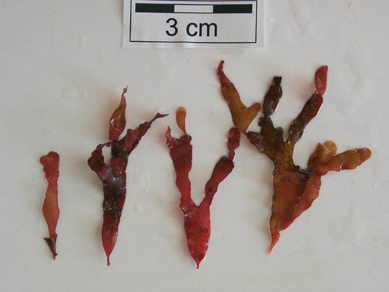
Sandy leaf bearer (Phyllophora crispa)
Distribution data supplied by the Ocean Biodiversity Information System (OBIS). To interrogate UK data visit the NBN Atlas.Map Help
| Researched by | Jessica Heard | Refereed by | Admin |
| Authority | (Hudson) P.S.Dixon, 1964 | ||
| Other common names | - | Synonyms | - |
Summary
Description
A bright red or pink seaweed. Each plant has a small disk-shaped base and erect fronds. The fronds consist of short cylindrical stipes (stalks) rarely longer than 1cm long and blades which may be up to 15 cm long and 10 mm wide. The fronds are dichotomously branched, with undulating margins and an indistinct midrib. The tip of each frond is distinctly rounded. The fronds are perennial and in some case 5 or 6 new periods of growth can be identified. Regeneration occurs following erosion or animal grazing. Continual regeneration leads to great variation in the appearance of individual plants as each new growth could come from the end, margin or surface of the blade. Fronds are frequently encrusted with the spiral tube worm Spirorbis spirorbis or bryozoans.
Recorded distribution in Britain and Ireland
Phyllophora crispa occurs on all coasts around the British Isles. Records from eastern England are few, probably reflecting a lack of suitable substrata.Global distribution
-Habitat
Phyllophora crispa grows on rock subtidally to depths of 30 m and is commonly found in shady pools in lower intertidal areas.Depth range
-Identifying features
- Flat red or pink fronds.
- Short fronds with undulating margins.
- Tips of fronds are rounded.
- Holds its shape out of water.
- Due to continual regeneration, successive growth episodes on each plant can be easily identified.
Additional information
Phyllophora crispa is a cartilaginous seaweed and can, therefore, hold its shape out of water.
Listed by
- none -
Bibliography
Dixon, P.S. & Irvine, L.M., 1977. Seaweeds of the British Isles. Volume 1 Rhodophyta. Part 1 Introduction, Nemaliales, Gigartinales. London: British Museum (Natural History) London.
Guiry, M.D. & Nic Dhonncha, E., 2002. AlgaeBase. World Wide Web electronic publication http://www.algaebase.org,
Hardy, F.G. & Guiry, M.D., 2003. A check-list and atlas of the seaweeds of Britain and Ireland. London: British Phycological Society
Hiscock, S., 1986b. A field key to the British Red Seaweeds. Taunton: Field Studies Council. [Occasional Publication No.13]
JNCC (Joint Nature Conservation Committee), 1999. Marine Environment Resource Mapping And Information Database (MERMAID): Marine Nature Conservation Review Survey Database. [on-line] http://www.jncc.gov.uk/mermaid
Datasets
Centre for Environmental Data and Recording, 2018. Ulster Museum Marine Surveys of Northern Ireland Coastal Waters. Occurrence dataset https://www.nmni.com/CEDaR/CEDaR-Centre-for-Environmental-Data-and-Recording.aspx accessed via NBNAtlas.org on 2018-09-25.
Kent Wildlife Trust, 2018. Biological survey of the intertidal chalk reefs between Folkestone Warren and Kingsdown, Kent 2009-2011. Occurrence dataset: https://www.kentwildlifetrust.org.uk/ accessed via NBNAtlas.org on 2018-10-01.
Kent Wildlife Trust, 2018. Kent Wildlife Trust Shoresearch Intertidal Survey 2004 onwards. Occurrence dataset: https://www.kentwildlifetrust.org.uk/ accessed via NBNAtlas.org on 2018-10-01.
Manx Biological Recording Partnership, 2017. Isle of Man wildlife records from 01/01/2000 to 13/02/2017. Occurrence dataset: https://doi.org/10.15468/mopwow accessed via GBIF.org on 2018-10-01.
National Trust, 2017. National Trust Species Records. Occurrence dataset: https://doi.org/10.15468/opc6g1 accessed via GBIF.org on 2018-10-01.
NBN (National Biodiversity Network) Atlas. Available from: https://www.nbnatlas.org.
OBIS (Ocean Biodiversity Information System), 2025. Global map of species distribution using gridded data. Available from: Ocean Biogeographic Information System. www.iobis.org. Accessed: 2025-08-02
Royal Botanic Garden Edinburgh, 2018. Royal Botanic Garden Edinburgh Herbarium (E). Occurrence dataset: https://doi.org/10.15468/ypoair accessed via GBIF.org on 2018-10-02.
South East Wales Biodiversity Records Centre, 2018. SEWBReC Algae and allied species (South East Wales). Occurrence dataset: https://doi.org/10.15468/55albd accessed via GBIF.org on 2018-10-02.
Citation
This review can be cited as:
Last Updated: 14/02/2005


