Conger eel (Conger conger)
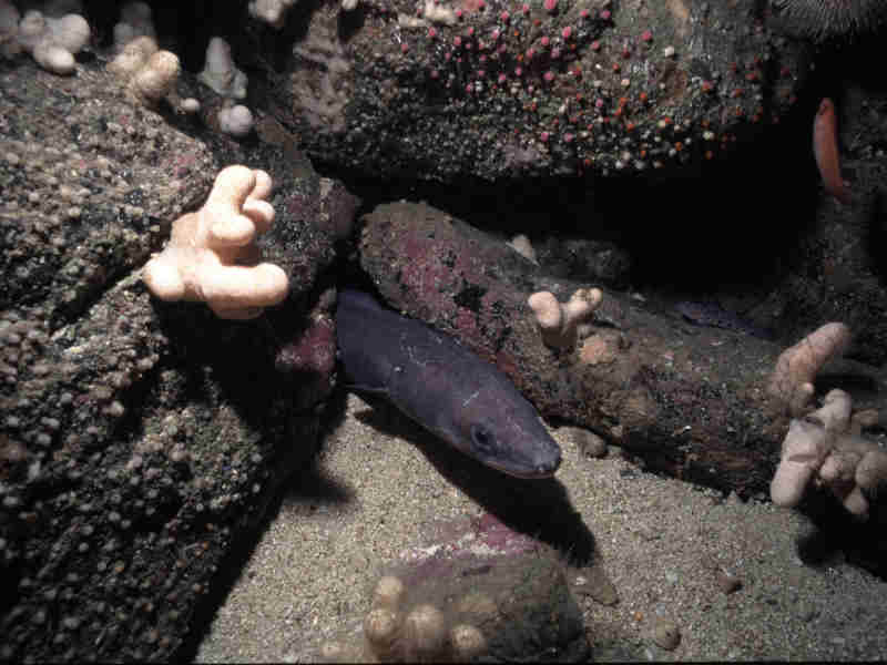
A conger eel Conger conger and a leopard spotted goby Thorogobius ephippiatus.
Photographer: Dr Keith Hiscock Copyright: Dr Keith Hiscock
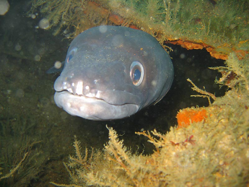
Conger conger on the City of Ghent, at the Manacles, southwest Cornwall.
Photographer: Robert Keen Copyright: Robert Keen
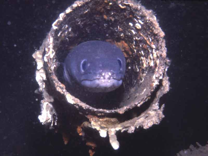
A conger eel in the funnel of the wreck of the MV Robert at Lundy.
Photographer: Dr Keith Hiscock Copyright: Dr Keith Hiscock
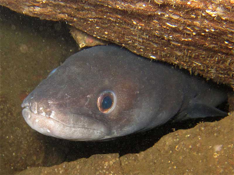
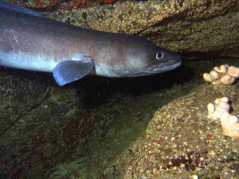
A conger in a hole.
Photographer: Gordon Lang Copyright: Gordon Lang
An active conger eel.
Photographer: Paul Newland Copyright: Paul Newland
Distribution data supplied by the Ocean Biodiversity Information System (OBIS). To interrogate UK data visit the NBN Atlas.Map Help
| Researched by | Al Reeve | Refereed by | Admin |
| Authority | (Linnaeus, 1758) | ||
| Other common names | - | Synonyms | - |
Summary
Description
Recorded distribution in Britain and Ireland
Conger conger is found predominantly on the south and western coasts of England, Wales and Scotland and all around the Irish coast. There are a few records on eastern coasts of England and Scotland though the conger is less numerous in these areas.Global distribution
-Habitat
During the day Conger conger are found in holes or crevices on rocky or sandy bottoms and in wrecks and other artificial environments. Conger eels become more active at night when they leave their resting places to hunt. Many Congers are found down to depths of 500 m but descend to as deep as 4000 m to spawn.Depth range
-Identifying features
- Dorsal, tail and anal fins fused forming a complete fringe with a pointed tail.
- The pectoral fins are pointed with the dorsal fin beginning just behind the pectoral tip.
- The eyes are eliptical and the upper jaw is longer than the lower.
- Nostril openings face forward on the snout.
- Grey-blue or grey-brown in colour with black margin around dorsal and anal fins.
- Long snake-like fish that grow up to 2.75 m in length.
Additional information
Conger eels spend their entire life in marine waters. Once they reach maturity, which takes between 5 -15 years, they migrate to deep water in the mid-Atlantic to spawn. Conger conger spawns only once and dies straight after. The larvae drift north eastwards until they reach shallower waters where larval development is completed (Wheeler, 1969). Conger conger could be confused with the common eel Anguilla anguilla. However, the conger eel has pointed pectoral fins, the upper jaw overhangs the lower and the dorsal fin originates from further forward on the body.Listed by
- none -
Bibliography
FishBase, 2000. FishBase. A global information system on fishes. [On-line] http://www.fishbase.org, 2001-05-03
Howson, C.M. & Picton, B.E., 1997. The species directory of the marine fauna and flora of the British Isles and surrounding seas. Belfast: Ulster Museum. [Ulster Museum publication, no. 276.]
JNCC (Joint Nature Conservation Committee), 1999. Marine Environment Resource Mapping And Information Database (MERMAID): Marine Nature Conservation Review Survey Database. [on-line] http://www.jncc.gov.uk/mermaid
MarLIN (Marine Life Information Network), 2005. SEArchable BEnthic Data (SEABED) Map [on-line]. Data Access Sub-programme, Marine Life Information Network for Britian and Ireland http://www.marlin.ac.uk,
Naylor, P., 2000. Marine Animals of the South West. Plymouth: Sound Diving Publications
Picton, B.E. & Morrow, C.C., 2000. Encyclopaedia of Marine Life of Britain and Ireland. http://www.habitas.org.uk/marinelife/index.html, 2003-09-18
Picton, B.E., & Costello, M.J., 2001. BioMar biotope viewer: a guide to marine habitats and fauna of Britain and Ireland. http://www.itsligo.ie/biomar/echinode/ECHSEP.HTM, 2001-06-01
Wheeler, A., 1969. The fishes of the British Isles and north-west Europe. London: Macmillan.
Whitehead, P.J.P., Bauchot, M.-L., Hureau, J.-C., Nielson, J. & Tortonese, E. 1986. Fishes of the North-eastern Atlantic and the Mediterranean. Vol. I, II & III. Paris: United Nations Educational, Scientific and Cultural Organisation (UNESCO).
Datasets
Centre for Environmental Data and Recording, 2018. Ulster Museum Marine Surveys of Northern Ireland Coastal Waters. Occurrence dataset https://www.nmni.com/CEDaR/CEDaR-Centre-for-Environmental-Data-and-Recording.aspx accessed via NBNAtlas.org on 2018-09-25.
Cofnod – North Wales Environmental Information Service, 2018. Miscellaneous records held on the Cofnod database. Occurrence dataset: https://doi.org/10.15468/hcgqsi accessed via GBIF.org on 2018-09-25.
Dorset Environmental Records Centre, 2018. Ross Coral Mapping Project - NBN South West Pilot Project Case Studies. Occurrence dataset:https://doi.org/10.15468/mnlzxc accessed via GBIF.org on 2018-09-25.
Fenwick, 2018. Aphotomarine. Occurrence dataset http://www.aphotomarine.com/index.html Accessed via NBNAtlas.org on 2018-10-01
Isle of Wight Local Records Centre, 2017. IOW Natural History & Archaeological Society Marine Records. Occurrence dataset: https://doi.org/10.15468/7axhcw accessed via GBIF.org on 2018-09-27.
Kent & Medway Biological Records Centre, 2017. Fish: Records for Kent. Occurrence dataset https://doi.org/10.15468/kd1utk accessed via GBIF.org on 2018-09-27.
Lancashire Environment Record Network, 2018. LERN Records. Occurrence dataset: https://doi.org/10.15468/esxc9a accessed via GBIF.org on 2018-10-01.
Merseyside BioBank., 2018. Merseyside BioBank (unverified). Occurrence dataset: https://doi.org/10.15468/iou2ld accessed via GBIF.org on 2018-10-01.
NBN (National Biodiversity Network) Atlas. Available from: https://www.nbnatlas.org.
OBIS (Ocean Biodiversity Information System), 2025. Global map of species distribution using gridded data. Available from: Ocean Biogeographic Information System. www.iobis.org. Accessed: 2025-08-08
South East Wales Biodiversity Records Centre, 2018. SEWBReC Fish (South East Wales). Occurrence dataset: https://doi.org/10.15468/htsfiy accessed via GBIF.org on 2018-10-02.
South East Wales Biodiversity Records Centre, 2018. Dr Mary Gillham Archive Project. Occurance dataset: http://www.sewbrec.org.uk/ accessed via NBNAtlas.org on 2018-10-02
Citation
This review can be cited as:
Last Updated: 14/03/2007
