An erect bryozoan (Bugula neritina)
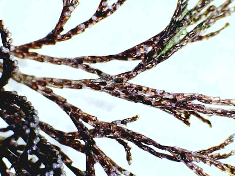
Closeup of the invasive bryozoan Bugula neritina.
Photographer: Holly Latham Copyright: Holly Latham
Distribution data supplied by the Ocean Biodiversity Information System (OBIS). To interrogate UK data visit the NBN Atlas.Map Help
| Researched by | Jaret Bilewitch | Refereed by | Admin |
| Authority | (Linnaeus, 1758) | ||
| Other common names | - | Synonyms | - |
Summary
Description
Recorded distribution in Britain and Ireland
Scattered marinas and harbours of Brighton (E. Sussex), the Solent (Hampshire), Poole and Weymouth (Dorset), Torquay and Plymouth (Devon) and Falmouth (Cornwall). Also found in Milford Haven and off the coast of Pembrokeshire in Wales.Global distribution
Found in New Zealand and along Atlantic and Gulf coasts of Florida, U.S.A. Sparse and disparate records exist from Belgian coast, Greece (Ionian & Adriatic Seas), Californian coast of U.S.A., Hawaii, Bay of Bengal and Australia.Habitat
Fouls artificial substrata such as ship hulls, docks, wharf pilings and immersed ropes.Depth range
-Identifying features
- Upright, foliose colonies reaching 8 cm height.
- Rhizoid attachment to substratum.
- Branches unilamellar and dividing dichotomously.
- Zooids large, 7.5 µm x 2.5 µm, lacking operculum.
- Zooids in alternating, biserial rows.
- Avicularia and spines absent.
- Colonies purplish-brown with pale brown embryos (when present).
Additional information
TaxonomyThere are at least three cryptic species contained within Bugula neritina (Linnaeus, 1758). A shallow water species, a deep water species and a North Atlantic species exist within the U.S.A. but only the shallow water species is known to invade other sites worldwide (Mackie et al., 2006).
Listed by
- none -
Bibliography
Datasets
Centre for Environmental Data and Recording, 2018. Ulster Museum Marine Surveys of Northern Ireland Coastal Waters. Occurrence dataset https://www.nmni.com/CEDaR/CEDaR-Centre-for-Environmental-Data-and-Recording.aspx accessed via NBNAtlas.org on 2018-09-25.
Fenwick, 2018. Aphotomarine. Occurrence dataset http://www.aphotomarine.com/index.html Accessed via NBNAtlas.org on 2018-10-01
Kent Wildlife Trust, 2018. Kent Wildlife Trust Shoresearch Intertidal Survey 2004 onwards. Occurrence dataset: https://www.kentwildlifetrust.org.uk/ accessed via NBNAtlas.org on 2018-10-01.
NBN (National Biodiversity Network) Atlas. Available from: https://www.nbnatlas.org.
OBIS (Ocean Biodiversity Information System), 2025. Global map of species distribution using gridded data. Available from: Ocean Biogeographic Information System. www.iobis.org. Accessed: 2025-08-05
West Wales Biodiversity Information Centre, 2018. INNS Data: All Taxa (West Wales). Occurrence dataset: https://doi.org/10.15468/ydifzd accessed via GBIF.org on 2018-10-02.
Citation
This review can be cited as:
Last Updated: 28/07/2009
