A sea anemone (Actinauge richardi)
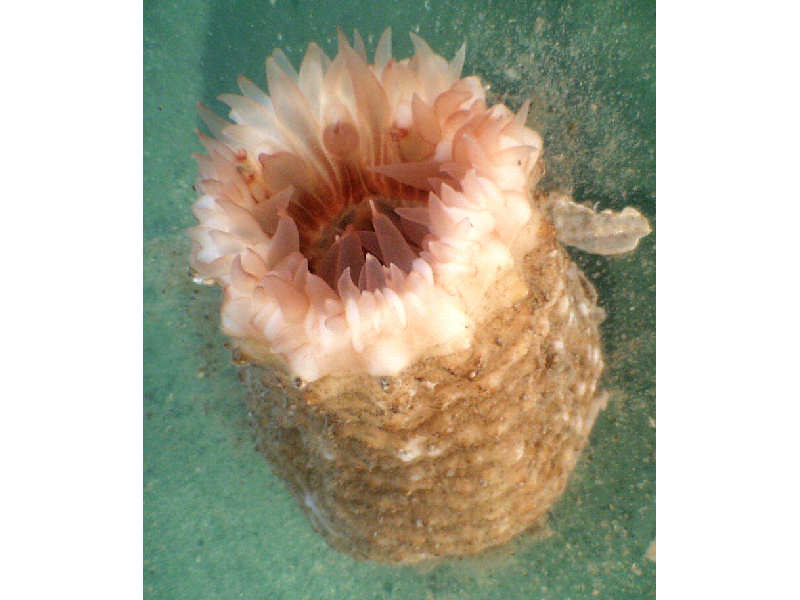
Actinauge richardi specimen showing column.
Photographer: Hilmar Hinz Copyright: Dr Hilmar Hinz
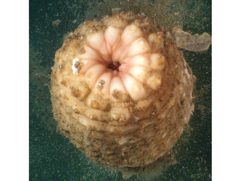
Actinauge richardi, tentacles retracted.
Photographer: Hilmar Hinz Copyright: Dr Hilmar Hinz
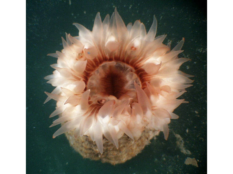
Close up of tentacles of Actinauge richardi.
Photographer: Hilmar Hinz Copyright: Dr Hilmar Hinz
Distribution data supplied by the Ocean Biodiversity Information System (OBIS). To interrogate UK data visit the NBN Atlas.Map Help
| Researched by | Jaret Bilewitch | Refereed by | This information is not refereed |
| Authority | (Marion, 1882) | ||
| Other common names | - | Synonyms | - |
Summary
Description
A sea anemone with a thick, muscular, column with limited contraction, and a hemispherical base. The base typically clutches a ball of mud in order to anchor the anemone in soft seabeds. The species can reach 12 cm in height and 8 cm in diameter when fully expanded. The lower column (scapus) is covered with tubercles that tend to form 12 longitudinal rows and which terminate at the upper column (scapulus) as a ring of 12 prominent warts. The upper scapulus has 12 pairs of longitudinal ridges, each terminating at a scapal wart. The anemone has 96 tentacles contained in 5 cycles, with those of the inner 4 having a swelling at their base. The colour is highly variable. The tentacles may be white, red, brown or intermediate shades and often have longitudinal stripes. The column is coloured dirty white, sometimes with red or green tinges.
Recorded distribution in Britain and Ireland
A sublittoral species recorded from the west coasts of the British Isles and the North Sea.
Global distribution
Found in the North East Atlantic from Norway and the Shetlands to the Mediterranean and north-west Africa, and recorded of the north-east coasts of South America (Stephensen, 1935; Manuel, 1988).
Habitat
Inhabits muddy or sandy bottoms, always offshore. Usually lives free by using balls of mud as anchoring bases but can occasionally be found attached to stones or shells. This is a deep water species occurring below 70 m in depth. Stephensen (1935) reported its greatest abundance below 2000 m.Depth range
70 m - 2000 mIdentifying features
- Anchored to substratum by a concave hemispherical base, which clutches a ball of mud, stones or shells.
- Column thick and muscular, poorly contractile, divided into lower scapus and upper scapulus.
- Scapus covered with tubercles, often in 12 longitudinal rows.
- Each row terminates in prominent tubercle, forming a ring of 12 below the scapulus.
- Scapulus with 24 longitudinal ridges converging in pairs to meet tubercles at scapus margin.
- Scapulus holds 96 tentacles in 5 cycles, the inner 4 cycles with swellings on the tentacle bases.
- Tentacles white, red, or brown, often with longitudinal stripes.
- Column dirty white, sometimes tinged with red or green.
- When fully expanded, the anemone can reach 12 cm in height and 8 cm in diameter.
Additional information
Actinauge richardi stabilizes itself by invaginating its column to enclose a ball of sediment at its base although it is also capable of normal attachment on stones or shells (Manuel, 1988).
Listed by
Bibliography
Manuel, R.L., 1988. British Anthozoa. Synopses of the British Fauna (New Series) (ed. D.M. Kermack & R.S.K. Barnes). The Linnean Society of London [Synopses of the British Fauna No. 18.]. DOI https://doi.org/10.1002/iroh.19810660505
Stephenson, T.A., 1935. The British Sea Anemones, vol. 2. London: Ray Society.
- Fautin, D., Zelenchuk, T. & Raveendran, D., 2007. Genera Of Orders Actiniaria And Corallimorpharia (Cnidaria, Anthozoa, Hexacorallia), and their type species. Zootaxa, 1668.
- O'Riordan, C.E., 1979. Marine Fauna Notes from the National Museum of Ireland-V1. The Irish Naturalists' Journal, 19 (10), 356-358
Datasets
NBN (National Biodiversity Network) Atlas. Available from: https://www.nbnatlas.org.
OBIS (Ocean Biodiversity Information System), 2025. Global map of species distribution using gridded data. Available from: Ocean Biogeographic Information System. www.iobis.org. Accessed: 2025-07-19
Citation
This review can be cited as:
Last Updated: 01/08/2018
