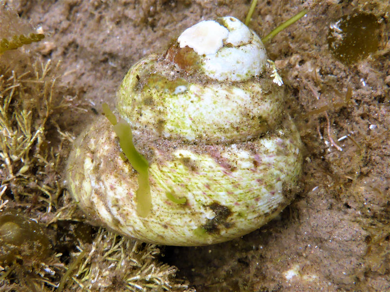
Turban top shell (Gibbula magus)
Distribution data supplied by the Ocean Biodiversity Information System (OBIS). To interrogate UK data visit the NBN Atlas.Map Help
| Researched by | Chloe Wilson | Refereed by | Admin |
| Authority | (Linnaeus, 1758) | ||
| Other common names | - | Synonyms | Trochus magus (Linnaeus, 1758), Gibbula forskadauri (Nordsieck, 1982) |
Summary
Description
A large top shell usually broader than it is tall (up to 3.5 cm high and 3.0 cm across). The shell is blunt and conical. The base of the shell bears a wide and deep central cavity (umbilicus) outlined by a thick ridge partly obstructed by the inner lip. The shell is stepped with up to eight whorls, each with a variable number of ridges and grooves. Round bumps (tubercles) are found on the upper surfaces of the whorls. The shell colour varies from white to grey to yellowish. The shell is decorated with irregular flecks of red, brown or purple. Intertidal specimens may be markedly smoother than those found in the subtidal.
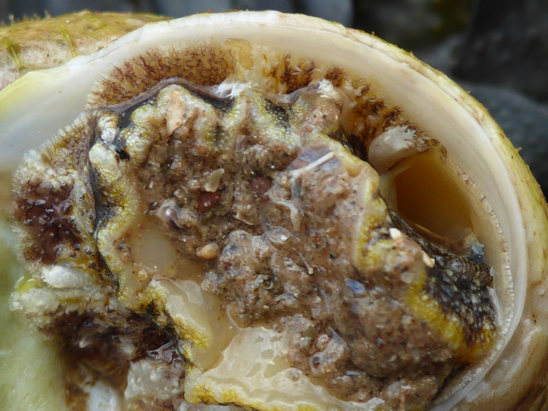
The animal itself is yellow-pink or orange in colour with black or purple spots. The front of the foot is blunt whilst the back is pointed and has three pairs of sulphur yellow tentacles with white sheaths. A rounded plate (operculum) closes the shell opening when the body is withdrawn into the shell.
Recorded distribution in Britain and Ireland
Found at all latitudes in Britain from north Scotland to the south west of England and along the English Channel. Records are concentrated on western coasts, with few records from the east coast and the North Sea. In Ireland, Gibbula magus is patchily distributed around all coasts.
Global distribution
Gibbula magus is found in parts of the North East Atlantic, extending north from the eastern Mediterranean (Egypt) and the Azores to its northern limits in the Shetland Islands, Scotland.
Habitat
Restricted to the extreme low water of spring tides (ELWST) in the intertidal, where it is found on shingle or rocky substrata under stones and on weed. It is found at depths of up to 70 m in the subtidal on rock, muddy gravel, and muddy sand.
Depth range
ELWST to 70 mIdentifying features
- Solid, large, and bluntly conical top shell, usually broader than it is tall, up to 3.5 cm high and 3.cm across.
- Large and deep umbilicus.
- Shell has up to eight whorls, forming a steeply stepped profile.
- The shell is white, yellowish or grey in colour, irregularly marked with darker red, brown or purple blotches and streaks.
Additional information
Food sources include microbes and detritus (Fish & Fish, 1996). They are dioecious and eggs are laid only in the spring and early summer after external fertilization (Graham, 1988; Fish & Fish, 1996).
Listed by
- none -
Bibliography
Fish, J.D. & Fish, S., 1996. A student's guide to the seashore. Cambridge: Cambridge University Press.
Graham, A., 1988. Molluscs: prosobranchs and pyramellid gastropods (2nd ed.). Leiden: E.J. Brill/Dr W. Backhuys. [Synopses of the British Fauna No. 2]
Hayward, P., Nelson-Smith, T. & Shields, C. 1996. Collins pocket guide. Sea shore of Britain and northern Europe. London: HarperCollins.
Hayward, P.J. & Ryland, J.S. (ed.) 1995b. Handbook of the marine fauna of North-West Europe. Oxford: Oxford University Press.
Hayward, P.J. & Ryland, J.S. (ed.), 1995. The marine fauna of the British Isles and north-west Europe. Volume 2. Molluscs to Chordates. Oxford Science Publications. Oxford: Clarendon Press.
Datasets
Centre for Environmental Data and Recording, 2018. Ulster Museum Marine Surveys of Northern Ireland Coastal Waters. Occurrence dataset https://www.nmni.com/CEDaR/CEDaR-Centre-for-Environmental-Data-and-Recording.aspx accessed via NBNAtlas.org on 2018-09-25.
Cofnod – North Wales Environmental Information Service, 2018. Miscellaneous records held on the Cofnod database. Occurrence dataset: https://doi.org/10.15468/hcgqsi accessed via GBIF.org on 2018-09-25.
Conchological Society of Great Britain & Ireland, 2018. Mollusc (marine) data for Great Britain and Ireland - restricted access. Occurrence dataset: https://doi.org/10.15468/4bsawx accessed via GBIF.org on 2018-09-25.
Conchological Society of Great Britain & Ireland, 2023. Mollusc (marine) records for Great Britain and Ireland. Occurrence dataset: https://doi.org/10.15468/aurwcz accessed via GBIF.org on 2024-09-27.
Fenwick, 2018. Aphotomarine. Occurrence dataset http://www.aphotomarine.com/index.html Accessed via NBNAtlas.org on 2018-10-01
Manx Biological Recording Partnership, 2022. Isle of Man historical wildlife records 1990 to 1994. Occurrence dataset:https://doi.org/10.15468/aru16v accessed via GBIF.org on 2024-09-27.
National Trust, 2017. National Trust Species Records. Occurrence dataset: https://doi.org/10.15468/opc6g1 accessed via GBIF.org on 2018-10-01.
NBN (National Biodiversity Network) Atlas. Available from: https://www.nbnatlas.org.
OBIS (Ocean Biodiversity Information System), 2025. Global map of species distribution using gridded data. Available from: Ocean Biogeographic Information System. www.iobis.org. Accessed: 2025-07-26
Outer Hebrides Biological Recording, 2018. Invertebrates (except insects), Outer Hebrides. Occurrence dataset: https://doi.org/10.15468/hpavud accessed via GBIF.org on 2018-10-01.
Citation
This review can be cited as:
Last Updated: 18/08/2017
- topshell
- top-shell


