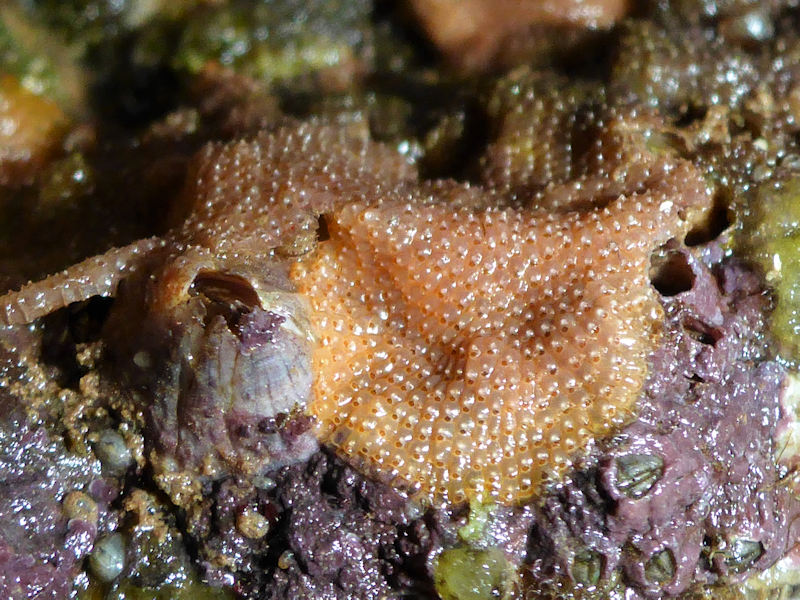
A sea mat (Schizoporella unicornis)
Schizoporella unicornis
Photographer: Michael Puleston Copyright: Michael Puleston
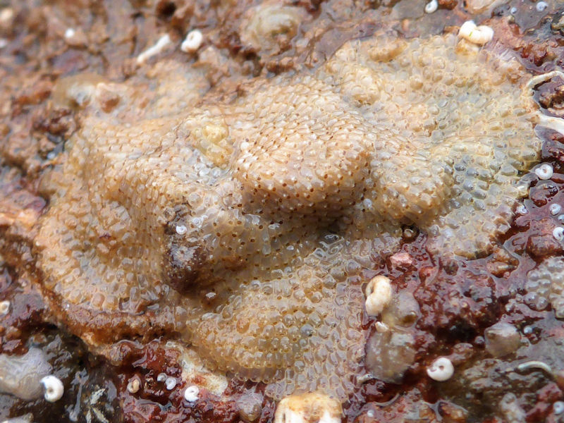
Schizoporella unicornis on rocky substratum
Photographer: Michael Puleston Copyright: Michael Puleston
Distribution data supplied by the Ocean Biodiversity Information System (OBIS). To interrogate UK data visit the NBN Atlas.Map Help
| Researched by | Chloe Wilson | Refereed by | Admin |
| Authority | (Johnston in Wood, 1844) | ||
| Other common names | - | Synonyms | - |
Summary
Description
Schizoporella unicornis forms sheets with one or more layers of zooids on various substrata on the lower shore. The whitish or pink colonies coat hard surfaces such as stones and shells or the holdfasts of large algae (e.g. Himanthalia and Laminaria). The zooids are arranged in a regular pattern. Individual zooids are convex, usually rectangular in shape, and typically 0.4 - 0.7 mm x 0.3 - 0.5 mm in size. Deep grooves mark the boundaries between the zooids. Each zooid has a D-shaped orifice with a V-shaped indentation in the middle of the straight edge. A single or pair of raised avicularia sit either side of the orifice. Later in development, a conical umbo (small projection) appears directly below the V-shaped sinus of each primary orifice.
Recorded distribution in Britain and Ireland
Common on all British and Irish coasts, although under reported on some coasts (particularly around Ireland).Global distribution
Schizoporella unicornis is scattered circumglobally, mainly in temperate coastal regions. Most records are located in the northern hemisphere, with colonies commonly occurring on the West and East coasts of the USA, the British Isles and the Northeastern Mediterranean. However, it has also been recorded in the tropics (e.g. Hawaii and Port Sudan). In the southern hemisphere, Schizoporella unicornis has been found at a single location near Curitiba, Brazil.
Habitat
Colonizes a variety of substrata from the lower shore to the shallow sublittoral. These include the underside of rocks and shells, Himanthalia buttons and Laminaria holdfasts.Depth range
Lower Shore - Shallow SublittoralIdentifying features
- Polygonous (typically rectangular) zooids, approximately 0.4 - 0.7 mm x 0.3 - 0.5 mm.
- Colonies form uni or multilaminar sheets.
- Primary orifices are D-shaped and wider than long.
- Polypide has 21-24 tentacles.
- Ovicell is globular and lacks pores (imperforate).
- Avicularia with acute triangular rostra are present either singularly or in pairs on each zooid.
- External surface of zooids is densely perforated by round pores.
Additional information
-none-Listed by
- none -
Bibliography
Hayward, P.J. & Ryland, J.S. (ed.), 1995. The marine fauna of the British Isles and north-west Europe. Volume 2. Molluscs to Chordates. Oxford Science Publications. Oxford: Clarendon Press.
Hayward, P.J. & Ryland, J.S. 1999. Cheilostomatous Bryozoa. Part II Hippothooidea - Celleporoidea. London: Academic Press. [Synopses of the British Fauna, no. 14. (2nd edition)]
Porter, J., 2012. Seasearch Guide to Bryozoans and Hydroids of Britain and Ireland. Ross-on-Wye: Marine Conservation Society.
Datasets
Centre for Environmental Data and Recording, 2018. Ulster Museum Marine Surveys of Northern Ireland Coastal Waters. Occurrence dataset https://www.nmni.com/CEDaR/CEDaR-Centre-for-Environmental-Data-and-Recording.aspx accessed via NBNAtlas.org on 2018-09-25.
Fenwick, 2018. Aphotomarine. Occurrence dataset http://www.aphotomarine.com/index.html Accessed via NBNAtlas.org on 2018-10-01
Kent Wildlife Trust, 2018. Biological survey of the intertidal chalk reefs between Folkestone Warren and Kingsdown, Kent 2009-2011. Occurrence dataset: https://www.kentwildlifetrust.org.uk/ accessed via NBNAtlas.org on 2018-10-01.
Kent Wildlife Trust, 2018. Kent Wildlife Trust Shoresearch Intertidal Survey 2004 onwards. Occurrence dataset: https://www.kentwildlifetrust.org.uk/ accessed via NBNAtlas.org on 2018-10-01.
NBN (National Biodiversity Network) Atlas. Available from: https://www.nbnatlas.org.
OBIS (Ocean Biodiversity Information System), 2025. Global map of species distribution using gridded data. Available from: Ocean Biogeographic Information System. www.iobis.org. Accessed: 2025-08-08
South East Wales Biodiversity Records Centre, 2023. SEWBReC Marine and other Aquatic Invertebrates (South East Wales). Occurrence dataset:https://doi.org/10.15468/zxy1n6 accessed via GBIF.org on 2024-09-27.
Citation
This review can be cited as:
Last Updated: 10/10/2017
- Bryozoa
- bryozoan
